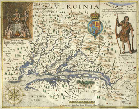

Four hundred years ago, Captain John Smith took a 30-foot long open sailing vessel and explored the Chesapeake Bay, making very astute observations along the way and creating a map that would be recognizable to modern mariners. For most of the next century it would be Smith’s map that would be the gold standard for boats plying the Bay.
So many things are instantly recognizable; the Virginia capes, the Potomac and Susquehanna Rivers and various Native American settlements which retain their ancient names.
When one looks at the map, the most striking image is the dendritic pattern of rivers. The Chesapeake estuary (the drowned river valley of the Susquehanna), was fed by fresh water from every direction. This was not a land of basins and ponds. There were no 10,000 lakes of Minnesota, in fact Maryland does not have a single natural lake. The rain that fell on the land for 64,299 square miles around the Chesapeake Bay ended up in the Chesapeake Bay.
It is quite interesting to note that rain that falls in Cooperstown, N.Y. (300 miles from Havre de Grace at the head of the Bay’s watershed) wends its way via the Susquehanna through the entire state of Pennsylvania and empties into the Chesapeake Bay. Yet, on the other hand, rain that falls just 25 miles from Havre de Grace in the northeast corner of Maryland, drains into the Delaware River/Bay. This is an elongated watershed, north to south, covering large portions of six states and all of the District of Columbia.

As good as Smith’s map was for its day, especially since marine chronometers for measuring longitude were still over 150 years away, the future Baltimore Harbor is not distinct. That does not mean that Smith ignored it in that summer of 1608!
"We passed many shallow creeks, but the first we found navigable for a ship, we called Patapsco…."
Whereas many areas along coastal North America had been cleared by the native peoples for agricultural purposes, the future Baltimore Harbor was not. It was heavily forested right down to the water. Moreover, for water quality this meant a clarity that is now not even a memory. Fish, oysters and wildlife were plentiful because the land was green.
It was the trees, the marshes and the Bay grasses which kept the Chesapeake pristine. These held back the soil. These filtered out the pollutants. Perhaps Captain Smith was exaggerating, he was prone to do that, but there is little doubt that what he reported really did demonstrate an abundance which has been decimated over the centuries:
“A few Bevers, Otters, Beares, Martins and minkes we found, and in divers places that aboundance of fish, lying so thicke with their heads above the water, as for want of nets (our barge driving amongst them) we attempted to catch them with a frying pan: but we found it a bad instrument to catch fish with: neither better fish, more plenty, nor more variety for smal fish, had any of us ever seene in any place so swimming in the water, but they are not to be caught with frying pans.”
John Smith wrote these words just one year after the founding of Jamestown, the first permanent English settlement in what would become the United States. Following a rocky start, the Virginia, and then Maryland, settlements spread rapidly throughout the Chesapeake region. These were different from the native settlements largely due to two factors: gunpowder and steel. Sharp tools could rapidly remove a forest; muskets and shot could wipe out the wildlife that the forest destruction had not already destroyed. Who wanted a forest when a farm could be created to plant tobacco? Overseas trade in tobacco meant cold hard cash. Indeed, tobacco was cold hard cash.
So what does all this have to do with surface water?
As the population grew, more and more of the natural landscape disappeared.
Tobacco and corn tended to wear out the soil and fields were abandoned. Rain and snowmelt carried away the soil to the nearest river, destroying the habitat of the grasses, the fish and the wildlife.
In addition to this, the streams were viewed as dumping grounds for anything and everything. When towns like Baltimore (1729) were developed, the concentrated populations put even more pressure on the local streams. Roads and industries, buildings and bridges all did their part to accelerate runoff.
Even in colonial times it became clear that runoff was having an impact on commerce. Small port towns suddenly found themselves landlocked unless the local river was dredged.
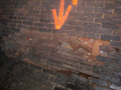
By the late 19th century, in an effort to manage floods and protect property, Baltimore and various other population centers had placed many streams in man-made channels or in massive pipes. In Baltimore, contractors installed storm water mains in 1873 (as far back as records go). The first record of installation on Druid Hill Avenue was a 54” to 72”, 1700-foot long, “storm sewer” pipe. Over the next 25 years, the City installed storm drains on many streets including Charles, Barclay, Stricker, Lanvale, Chase, Milton, Lakewood and Luzerne. Materials used for Baltimore’s storm drains include brick, concrete, metal, and even wood in some cases.
The present system now includes over 50,000 storm drain inlets and 1,100 miles of storm drains.
By the second half of the 19th century, gigantic factories had emerged along the water’s edge to produce steel for the skyscrapers and the railroads, to convert wood into newspapers, books and magazines, or to process agricultural and seafood harvests. By-products were both dumped into the Bay’s tributaries or were allowed to run-off with each rainstorm.
By the turn of the century, the Lower Jones Falls had become “an odorous, poisonous water hole” according to a local Baltimore paper of the time. Sewage, and stormwater ran into the river, and the factories and mills along its banks poured industrial waste into the Jones Falls. Baltimore had attained the highest typhoid rate in the country, and public health officials encouraged the conversion of the last two miles of the river into an underground drain. A major engineering operation channeled the river into a huge culvert emerging at the Inner Harbor. The City completed the project by 1915, and at the dedication the master of ceremonies, Henry Barton Jacobs claimed he had come to “bury the Jones Falls—not to praise it”.
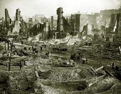
 On February 7, 1904, the Great Baltimore Fire destroyed downtown but it provided the impetus to rebuild bigger and better. In 1905, voters backed a plan for a comprehensive system of building separate storm and sanitary sewers including primary and secondary treatment of human and industrial wastes before returning the treated wastewater to the Bay. A sewage treatment facility was planned, and ultimately built, at Back River in Baltimore County.
Building separate systems for storm water and wastewater meant that less treatment capacity was required. Most ccities that installed their sewage collection systems before the 1930s typically used single piping systems to transport both urban storm water runoff and sewage. This is called a combined sewer system (CSS). Cities built these systems because they were cheaper than building a storm drain system and a separate sanitary system.
In a CSS, a sudden large rainfall that exceeds sewage treatment capacity can overflow directly from the storm drains into streams via structures called combined sewer overflows. Fortunately, Baltimore built a separate system for almost the entire City, more expensive in the beginning, but vastly preferable over a combined system. On the other hand, the 21st century storm water mandates mean that some form of treatment will be necessary after all for storm water.
As ships grew in size the Bay itself became a problem; it was too shallow due to centuries of siltation. By the 1970’s, the problems of how to dredge and where to place the spoils became major economic, environmental and political issues. This was no longer just mud in the channels, but heavy metals, petrochemicals and bacteria. The burgeoning environmental movement and federal legislation marked the beginning of the long process of restoring damages done over the centuries.
The Baltimore forests are gone. The Bay grasses are struggling. The runoff continues. Forest Park, Roland Park, Greenmount Avenue, Arcadia, Herring Run and other places with bucolic names contribute lawn and garden fertilizers, animal waste, trash, oil and grease, in varying amounts, to our estuary. These make their way, via the storm drains and streams, to the Chesapeake.
In 1612, the chronicler John Smith said: “heaven and earth never agreed better to frame a place for man's habitation”. This is certainly borne out by the millions who call the Bay region their home. It is not the same Bay as it was 400 years ago, but it can and should be a healthy and beautiful place for us and for future generations.
Looking back on this history it appears that Baltimore met the challenges of stormwater and sewage a century ago. But challenges do not end. Drains are planned, trenches are dug and pipes are laid – and largely forgotten.
 In 1983, the EPA named Baltimore’s storm water as the most contaminated of 28 metropolitan regions. Additionally, the Baltimore area system of 3,100 miles of aging sewage pipes would often break, and raw sewage would pour into our streams. Our bodies of water became so polluted that they were dangerously unhealthy for swimming or fishing. To make matters worse, streams were covered over with roadways; runoff from the Jones Falls Expressway has further polluted that river...but Baltimore is once again meeting the challenges. From sewer main replacements and relining, to stream restorations and public education, Baltimore is beginning the process to restore our streams, harbor and bay.
The Baltimore Watershed Agreement formalizes the commitment of Baltimore City and Baltimore County to work together on the management and monitoring of shared watersheds. First signed in 2002 and renewed in 2006, the agreement acknowledges that geographic boundaries of watersheds are more appropriate for managing these important natural resources than political boundaries.